
| Summary |
|
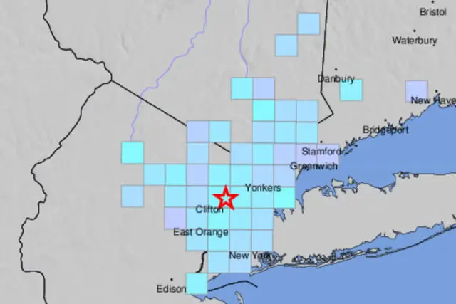
A 3.0-magnitude earthquake hit northern New Jersey late Saturday night, sending tremors through parts of New York City and surrounding areas. The quake struck at 10:18 p.m. on August 2, 2025, near Hasbrouck Heights in Bergen County, close to Teterboro Airport, reported the U.S. Geological Survey (USGS).
Residents felt the ground shake, but no major damage or injuries were reported, leaving the region more startled than harmed. The U.S. Geological Survey (USGS) located the epicenter at a shallow depth of about 6 miles, with tremors reaching Brooklyn, Westchester County, and parts of Connecticut.
“Be prepared for possible aftershocks. These may follow minutes, hours, or even days after the initial quake,” advised the New York City Emergency Management Department on X. “No immediate protective action is needed unless you experienced damage. If you felt shaking, check for hazards such as shifted items, falling debris, or cracks.”
Social media lit up with posts about the quake, with many describing a brief rumble that interrupted their evening routines. Most residents seemed more surprised than shaken, turning to social media to confirm what they had just felt.
“OMG, we just had an earthquake and had no clue. I thought someone drove into our building!” posted a user on X. “I was running around frantically trying to figure out what was happening!”
This quake likely ties back to the 4.8-magnitude earthquake that hit on April 5, 2024, centered in Tewksbury Township, New Jersey, the strongest in the state in over a century. That event shook buildings from Virginia to Maine, caused a sinkhole on Long Island, and damaged a school gym in East New York.
Are Earthquakes in New York and New Jersey rare?
Earthquakes in the New York–New Jersey region aren’t common, but they’re not unheard of either. The area sits near a fault system known as the Ramapo Fault, which stretches from eastern Pennsylvania through New Jersey and into New York. While it doesn’t produce frequent quakes like fault lines on the West Coast, it is considered the most active seismic zone in the northeastern U.S.
Most earthquakes in this region are small, often below magnitude 3.0, and are rarely felt. Stronger ones are much rarer.
According to geological records, only a handful of quakes stronger than magnitude 4.5 have been recorded here since the 1700s. The most notable was in 1884, when a magnitude 5.2 earthquake struck near New York City. That event damaged chimneys, cracked walls, and shook buildings across the region. Fortunately, no deaths were reported.
Scientists say that the risk of a large, damaging earthquake in the region is low, but not zero!
One challenge is that many faults in the Northeast are buried and not well mapped, making it hard to predict where stress might build up. Also, because of the way seismic energy travels through the dense rock of the eastern U.S., even moderate earthquakes here can be felt over much greater distances compared to similar quakes in the West.
That effect was clearly seen during the April 2024 quake near Tewksbury, New Jersey. It displayed an unusual shaking pattern: people near the epicenter reported mild or no movement, while tremors were felt more strongly farther away, even in places like Connecticut and New Hampshire. Researchers believe the seismic energy may have reflected off deep underground rock layers, amplifying the shaking in unexpected locations.
These quirks make the region’s earthquake risk hard to measure. But experts agree that the area’s aging infrastructure, including older buildings, roads, and bridges, could make even a moderate quake more dangerous. That’s why earthquake preparedness is still important.
For now, scientists are monitoring the Ramapo Fault for further activity, analyzing whether it could produce another surprise.